Auckland Harbour Bridge |
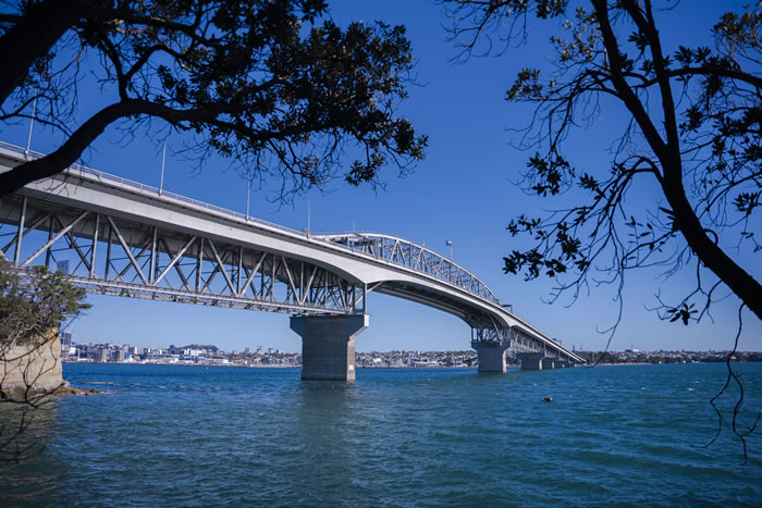
Standing sentinel across the Waitemata Harbour, Auckland Harbour Bridge connects the central business district to the North Shore and beyond to Northland.
Situated on the nation's main artery State Highway 1, more than a billion cars have travelled across the steel bridge since constructed.
There are actually three bridges within the Auckland Harbour Bridge. The section in the middle with the steep arches and flags on top is the original four-lane 'truss' bridge, plus the two clip-ons.
Auckland Harbour Bridge facts
-:- The Auckland Harbour Bridge was opened on 30 May, 1959
-:- In 1959, 11,205 vehicles crossed the bridge daily.
-:- The daily average number of cars crossing the bridge is presently around 154,000, with more than 200,000 vehicle crossings some days [Northern Busway has had impact on car numbers as people switch to public
transport]
-:- Cars and taxis were tolled 2 shillings and 6 pence -25c - that's about $4.70 in today's money compared with $2 for cars to use the Northern Gateway Toll Road],
-:- It was built at a cost of £7,516,000, $24 million in today's terms
-:- A team of 1000 took four years to build the bridge
-:- Constructed of structural steel and reinforced concrete, the bridge spans 1.2 kilometres across the Waitemata Harbour
-:- The bridge reaches 64 metres above the water at its highest point, the top of the arch
-:- There are actually three bridges within the Auckland Harbour Bridge. The section in the middle with the steep arches and flags on top is the original four-lane 'truss' bridge, plus the two clip-ons.
-:- Clip-ons added in 1969 to provide more capacity
-:- Tolls removed in 1984
-:- Moveable lane barrier installed in 1990 to prevent head-on crashes and improve rush hour traffic flows.
-:- NZTA spends up to $4m on maintenance and resealing each year.
-:- Currently, about 160 people working on the bridge: 20 maintenance people and another 140 on the strengthening of the clip-ons
-:- The direct road link - plus two new water mains it carries - triggered massive development of North Shore which was mainly farmland and seaside villages when bridge opened.
-:- North Shore population has quadrupled in 50 years.
Before it opened in 1959, the only way passenger vehicles could cross the harbour was by ferry; a time consuming, expensive and infrequently made journey.
Messenger
❊ Address ❊
⊜ Auckland Bridge Auckland View Map
℅ Tāmaki Makaurau
❊ More Information ❊
www.nzta.govt.nz
➼ www.nzta.govt.nzUpdate This Page
✻ Featured ✻
Candlelight Concerts | New Zealand
One New Zealand Warriors vs Tigers - NRL Telstra Premiership - Round 4

Ballet of Lights: Sleeping Beauty in a Sparkling Show - Tauranga

✻ Advertiser ✻

✻ What's On ✻
✻ Experiences ✻
Comedy
Eat & Drink
Events Calendar
Exhibitions
Experiences
Family Friendly
Markets & Sales
Music
Sales
Sightseeing
Sport
Theatre

✻ Featured ✻
Candlelight Concerts | New ZealandOne New Zealand Warriors vs Tigers - NRL Telstra Premiership - Round 4
Ballet of Lights: Sleeping Beauty in a Sparkling Show - Tauranga
✻ Advertiser ✻
✻ What's On ✻
✻ Experiences ✻
Comedy
Eat & Drink
Events Calendar
Exhibitions
Experiences
Family Friendly
Markets & Sales
Music
Sales
Sightseeing
Sport
Theatre
✻ Featured ✻
Candlelight Concerts | New Zealand
New Zealand's best new experience is a concert by candlelight in a unique location brought to you by ..
One New Zealand Warriors vs Tigers - NRL Telstra Premiership - Round 4
New Zealand's team in the NRL (National Rugby League) is the mighty One New Zealand Warriors.
Home games ..
Ballet of Lights: Sleeping Beauty in a Sparkling Show - Tauranga
Ballet of Lights: Sleeping Beauty has arrived in Tauranga
This beloved tale is brought to life through ..
One New Zealand Warriors vs Tigers - NRL Telstra Premiership - Round 4
Ballet of Lights: Sleeping Beauty in a Sparkling Show - Tauranga


✻ Trending ✻
→ Auckland Harbour Bridge
→ T?kina - Wellington Convention and Exhibition Centre
→ Auckland Domain | Pukekawa
→ Top 12 Tourist Attractions in New Zealand
→ EziBuy: NZ's #1 Women's Fashion Store
→ Trustpilot: Customer Reviews
→ Shed 10 Queens Wharf
→ Albert Park | Auckland
→ QuickTix | Music Tours and Tickets - New Zealand
→ SkyCity Auckland
✻ Featured ✻
Candlelight Concerts | New Zealand
New Zealand's best new experience is a concert by candlelight in a unique location brought to you by ..
One New Zealand Warriors vs Tigers - NRL Telstra Premiership - Round 4
New Zealand's team in the NRL (National Rugby League) is the mighty One New Zealand Warriors.
Home games ..
Ballet of Lights: Sleeping Beauty in a Sparkling Show - Tauranga
Ballet of Lights: Sleeping Beauty has arrived in Tauranga
This beloved tale is brought to life through ..
One New Zealand Warriors vs Tigers - NRL Telstra Premiership - Round 4
Ballet of Lights: Sleeping Beauty in a Sparkling Show - Tauranga
✻ Trending ✻
→ Auckland Harbour Bridge
→ T?kina - Wellington Convention and Exhibition Centre
→ Auckland Domain | Pukekawa
→ Top 12 Tourist Attractions in New Zealand
→ EziBuy: NZ's #1 Women's Fashion Store
→ Trustpilot: Customer Reviews
→ Shed 10 Queens Wharf
→ Albert Park | Auckland
→ QuickTix | Music Tours and Tickets - New Zealand
→ SkyCity Auckland
→ T?kina - Wellington Convention and Exhibition Centre
→ Auckland Domain | Pukekawa
→ Top 12 Tourist Attractions in New Zealand
→ EziBuy: NZ's #1 Women's Fashion Store
→ Trustpilot: Customer Reviews
→ Shed 10 Queens Wharf
→ Albert Park | Auckland
→ QuickTix | Music Tours and Tickets - New Zealand
→ SkyCity Auckland